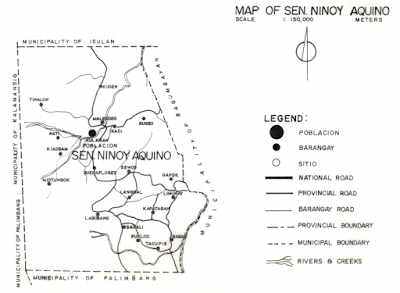
Population: 39,038 (projected for 2012, based on 2007 census)
Number of barangays: 20
Estimated distance from Isulan: 80 kilometers
Creation: February 17, 1989, Republic Act No. 6712, from Bagumbayan and Kalamansig
Literacy rate: 83.52% (household population 10 years old and above, 2000)
Population density: 102 persons per sq. km. (projected for 2012, based on 2007 census)
No. of households: 8,208 (projected for 2013, based on 2007 census)
Major industry: farming
Major crops: rice, corn, coffee
Land classification: agricultural, 17,365 has.; non-agricultural, 601 has.; fishing ground, 75 has.; total alienable and disposable land, 18,311 has. (2010)
Types of soils: mountain soils undifferentiated, Dadiangas loamy soil
Forest cover: total forest area, 3,000 has.; closed forest, 500 has.; grassland, 2000has.; mossy, 500 has. (2010)
Timberland area: 1,900 has., 4.97% of total land area (2010)Inland fishponds: 2.55 has.
Risk-prone areas: affected by drought, 1,216 has; prone to flooding 380 has. (2001)
Area planted by commodity: rice 2,013 has.; corn, 12,119 has. (2010), coffee, 2,785.4 has., coconut, 107.3 has; banana, 50 has.; mango, 31 has.; durian, 60 has.
Scenic spots: Kipulao Falls, Nati Spring, Midpanga Cave, Nati Seven Falls, and Paradise Cave and Falls in Nati; cave in Tinalon; Bugso Cave and Tudog Cave in Bugso; burial urns, Kilabuan Cave, Lagbasan Cave, Bitogon Cave, Batasan Cave, and Kalupingon Cave in Kuden; Saklay Cave in Malegdeg
No. of instructional classrooms: 136 (SY 2009–2010)
Schools: public elementary, 37; private elementary, 4; public secondary, 6; private secondary, 5; public tertiary, 1; private tertiary 1No. of instructional classrooms: 136 (SY 2009–2010)
Income: 64.46 million (2010)
Expenditure: 62.64 million (2010)
Internal revenue allotment: 63. 31 million (2010)
Real property tax collection: 1.08 million (2010)
Registered voters: 22,974 (2010)

No comments:
Post a Comment