Showing posts with label tourist spots. Show all posts

Saturday, March 5, 2016

The World-Class White Cave of Sultan Kudarat

Hidden in the mountains of South Central Mindanao, more than 900 meters above sea level, is a cave that is perhaps the most beautiful in the country and no doubt one of the most beautiful in the world. The cave, located in the village of Kuden in Senator Ninoy Aquino town, Sultan Kudarat province, was discovered just the previous decade, so it has been known only to the locals and to a handful of spelunkers, travel bloggers, and tourists. Though the underground paradise has been given the name “Lagbasan Cave,” after the Dulangan Manobo term for “bypass,” a more fitting name would be “White Cave,” for the cavern is swathed from the floor to the ceiling with immaculate white and cream-colored stone formations.

White Cave so far has been found to have at least three chambers, but for conservation reasons, only one is open to tourists. The chamber, though, offers more than enough. It is at least 40 meters wide, 50 meters high, and 250 meters long, and more than 80 percent of it is covered with stalactites, stalagmites, and other speleothems. The first ones to greet you are columns, many of which are taller than an average human being. Formed millimeter by millimeter over thousands of years, they look like corals piled on top of one another and then coated with milk. But don’t think that you’ve seen the best feature of the cave. The view gets more and more awe-inspiring as you walk further.


The floor of the cave is not even. It is composed of tiny hills filled with stone formations of various shapes and sizes, each one a beauty, like a garden of wild flowers left to grow freely. The tourist guide will lead you through a maze of flowstones, gypsum flowers, stalagmites, and columns, and to reiterate, these rocks and clusters of rocks are white or off-white. In some spots, you have to hold on to ropes to pull yourself up a slope or across a small crevice. The landscape is dreamlike, but some of the rocks, or their parts, uncannily resemble familiar objects, such as dog’s teeth, transparent straws, a large piggy bank, and a figurine of Cupid. At the end of the chamber is a flat area the size of a basketball court, and on one side of it is a mass of rock that looks like a huge multi-layered throne. On the opposite side is a long deep trench draped with stalactites.

An expert from the National Speleological Society of the United States, consulted by the Department of Tourism, explored White Cave in 2008 and called it world-class. He also said that some of the stone formations in the cave are so unusual that they do not fit existing classifications. But despite the seemingly hyperbolic yet accurate descriptions of the tourist spot, it has remained largely a secret. This is due to the remoteness of its location. From Isulan, the capital town of Sultan Kudarat, SNA is two to three hours away by jeepney, van, or skylab (public utility motorcycle). To get to Kuden from the capital village of SNA, you may hire a skylab or use your own vehicle. The trip takes fifteen to twenty minutes only. However, from the center of Kuden to its hamlet of Siokong, where White Cave is located, you have to travel again for two hours, and from the center of Siokong to the cave, you have to climb on foot a forested slope for forty minutes. You might wonder if seeing the cave is worth the effort. Among those who have been there, the answer is a resounding yes.


If you’re planning your next getaway, SNA might just be the perfect place for you. It’s destined to be the Sagada of Mindanao. Like the well-known backpacking destination in Luzon, SNA is mountainous and home to indigenous people—not Igorots, however, but Dulangan Manobos, one of the least documented lumads—though majority of the local population now is Ilonggos, Ilocanos, and Cebuanos who migrated to the area half a century ago. Similar to Sagada’s hanging coffins, SNA has limestone burial jars, estimated to be 1,500 years old, but these jars have not been preserved or curated in the town, and most of them have been taken away. (They are on display now at the Museum of the Filipino People in Luneta, the Ayalas-owned museums in Makati and Davao, the university museums in Cebu and Dumaguete, and in some private galleries.) Furthermore, White Cave is just one of the dozens of caves that SNA has, and coffee is flowing in the town. SNA produces about 25 percent of coffee in Sultan Kudarat, and Sultan Kudarat, the number 1 coffee-producing province in the Philippines, produces about 25 percent of coffee in the country.

To get to White Cave, you must coordinate with the local government of Kuden, for the village keeps the key—literally. To protect the cave from reckless adventurers and souvenir hunters, the local government installed at the narrow entrance a small door made of steel bars. The village also collects an entrance fee of P170 per head and imposes a minimum requirement of 10 tourists per visit. Solo backpackers or small groups are welcome, but you must pay the minimum fee. And to make sure you don’t get lost in Sultan Kudarat province, tell the people, especially the drivers, that you’re going to Kulaman, not Senator Ninoy Aquino or SNA. Though the town has been using its official name for almost thirty years, people in the province still use the name of the capital village even when referring to the whole town. In many local campaign materials, Kulaman is touted as a land of “a hundred caves with a thousand thrills.” That’s a fitting description. To experience the thousand thrills, though, you don’t have to visit all the one hundred caves or so. One cave, the White Cave of Kuden, is enough. More than enough.


(Blogger’s note: The photos above are owned by the tourism office of the municipality of Senator Ninoy Aquino. I wrote this piece for the travel website of a major television network, but I decided not to submit at the last minute. I don’t like the way the editor is handling contributions. The section of the site that I wanted to be part of is something like citizen journalism. I noticed, however, that the editor uses her own byline and then just mentions the source in the article. She must have reasons. Maybe the contributions are badly written and she has to do a lot of revisions. All the same, I believe that there is no enough justification to deprive contributors of due recognition. The website does not pay them after all, and it is part of the job of an editor to polish accepted submissions.)

Monday, December 21, 2015

The Twenty Caves of Sultan Kudarat

Based on official records, the province of Sultan Kudarat boasts of twenty caves that tourists can explore. Ten, or half of those caves, are found of course in the municipality of Senator Ninoy Aquino, often promoted as “the town with a hundred caves.” Three of the twenty caves are in the municipality of Bagumbayan, one in Kalamansig, two in Lebak, one in Isulan, and three in Columbio. Only the four caves in Isulan and Columbio are not located in or very near Kulaman Plateau.

The twenty caves are not all that the province has. They are simply the ones that are accessible to or frequented by tourists. There cannot be twenty caves only in the whole province because Senator Ninoy Aquino alone has dozens. The municipality can possibly live up to its seemingly hyperbolic epithet if all its natural tunnels are examined and listed. It’s also impossible that there are only one cave in Kalamansig and two caves in Lebak. Most of the land area of the two “coastal towns” has the same topography as Senator Ninoy Aquino. The area probably has dozens of caves too. The caves have not been discovered yet because the area is sparsely populated and controlled by a private logging company.

For now, tourists who want to go spelunking in Kalamansig only have the Pangaun Caves to visit. Note, though, that the name is in plural form. The caves, located in Barangay Sabanal, may have several mouths and have chambers that branch off in several directions, not just a single straight tunnel. (I haven’t been there, and I’m sorry that I’m not sure of my information.) In Lebak, tourists may explore a cave in Salangsang and a cave in Kalamongog that are named after the villages where they are located. Salangsang is where the burial jars that are now in Silliman University were excavated, so the cave there is historic aside from attractive.

The ten caves in Senator Ninoy Aquino are the following: Midpanga Cave in Nati, Tinalon Cave in Tinalon, Bugso Cave and Tudog Cave in Bugso, Saklay Cave in Malegdeg, and Kiabuan Cave, Lagbasan Cave, Bitogon (also called Casi) Cave, Batasan Cave, and Kalupingon Cave in Kuden. Lagbasan Cave is what I call White Cave in this blog, and the burial jars that are now at the University of San Carlos were taken from a cave in Kuden, though the sacred cave is probably not one of the touristy caves in the list.

Bagumbayan has Pitot Cave in Sto. NiƱo, Guano Cave in Masiag, and Maetas Cave in Titulok. I’ve explored Guano Cave last summer. Isulan has Kamanga Cave in Laguilayan. Though I heard that the hamlet of Kamanga is in the mountainous part of Isulan, it is populated by Maguindanawons and not by Dulangan Manobos, so I’m not counting the area as part of Kulaman Plateau.

The only part of Kulaman Plateau that has no cave for tourists is Palimbang. Again, this is not an indication that there is no cave at all in the municipality. Palimbang, in fact, may have as many caves as Senator Ninoy Aquino has. It’s just that its mountainous part is barely accessible. Most of the villages of Palimbang, a small fraction of the total land area, are located at the coast.

As mentioned earlier, most of the twenty caves in the list are in or very near Kulaman Plateau. Only the three caves in Columbio are quite far: Datalblao Cave in Datalblao, Panes Cave in Lasak, and Bombed Cave in Lasak and Eday. The existence of caves there, however, is not surprising if you’re aware that Columbio is “the other” mountain town of Sultan Kudarat, the one being Senator Ninoy Aquino.

I wish to explore all the caves above that are in Kulaman Plateau and share the trip with you in this blog—in words and photos. It’s a shame that I’ve only been to two out of the sixteen caves. If I get a few thousand bucks to spare in the future, I will go cave hopping—and burial jar hunting. From the experience, surely, I’ll be able to create more than a hundred posts.

(Photo: A stitched image of the mouth of Guano Cave, in Masiag village, Bagumbayan town)

Friday, December 4, 2015

Five Things to Do in Kulaman River


Several weeks ago, I was finally able to take a dip in Kulaman River. It had always been one of the things that I wanted to do, along with going to the original sites of limestone burial jars. The river has not been developed to cater to tourists, but there are some touristy things that you can do in it. Here’s some:

1. Swim, of course. Anywhere is good for this, but the best is the spot that is connected to the center of the town by a graded road. The spot is frequented by people, and it has a number of wide calm pools.

2. Ride the “ferry.” The bamboo raft is actually for travelers (and their motorcycles) who don’t want to take the slightly winding national highway. If you’re coming from or going to the west of the central village, taking the raft will save you a few kilometers of travel. If you just want to have fun and you’re willing to pay for it, the “driver” of the raft can take you across the river and then back again for a minimal fee. The fee for travelers is maybe five or ten pesos per head, and only at least three persons is required for every trip.

3. Check out the waterfall. It’s just near the river, but it’s hidden by weeds and trees. Though the fall is neither big nor very tall, wading through the river and trekking to the fall is a brief adventure that people of all ages can enjoy.

4. Jump off the bridge. No, don’t take your own life. Just stand on the waist-high railing of the bridge, leap, and dive into the water. I can’t guarantee your safety, of course, so do this with caution. Don’t do this at all unless you’ve seen locals your size and height doing it first.

5. Wash your vehicles. Save time by cleaning your scooter or wheels while you’re cleaning yourself. Just make sure no one is swimming downstream twenty meters from you. Also make sure that there are no horses or carabaos upstream twenty meters from you. The river is wide and long, and there’s enough space for everyone and everything.

Final warning: Don’t expect to come across an innocent barrio lass wrapped in a wet patadyong. That kind of scene is only for titillating films and for short stories set in the fifties. Most bathers in the river are men of all ages, from prepubescent boys to tottering grandfathers, and many of them are in well-worn cotton briefs.


Friday, November 13, 2015

A ‘Cultural Heritage Home’

To the right is the entrance to the RNDM sisters' compound,
which has facilities for Dulangan Manobos. 

I had been wishing Kulaman Plateau had something like a museum—a place that exhibits the traditional objects that the Dulangan Manobo people use. I was therefore delighted when I found out that such a place exists. It’s run not by the local government, as the case should ideally be, but by missionary Catholic nuns. It’s a little disappointing—though not wholly unexpected—to find out that religious and civic organizations still do more for indigenous people than the government does.

The Sisters of Our Lady of the Missions (RNDM) call the place Delesan Kailawan, which means “cultural heritage home.” It is situated beside Notre Dame of Kulaman, a school that offers basic education and run by the diocese. The Catholic Church and the priests’ compound are on the other side of the school. Delesan Kailawan is really a convent with added facilities for the Dulangan Manobo, especially women, who avail themselves of the scholarship grants, medical assistance, livelihood trainings, and other programs offered by the RNDM sisters. Sister Kikiwin and Sister Weeyyaa told me a few things about the work of their congregation, but I ought to go back there and ask them more about that. When I visited Delesan Kailawan, twice, I was pressed for time and I was too excited to see the Manobo objects and identify them.

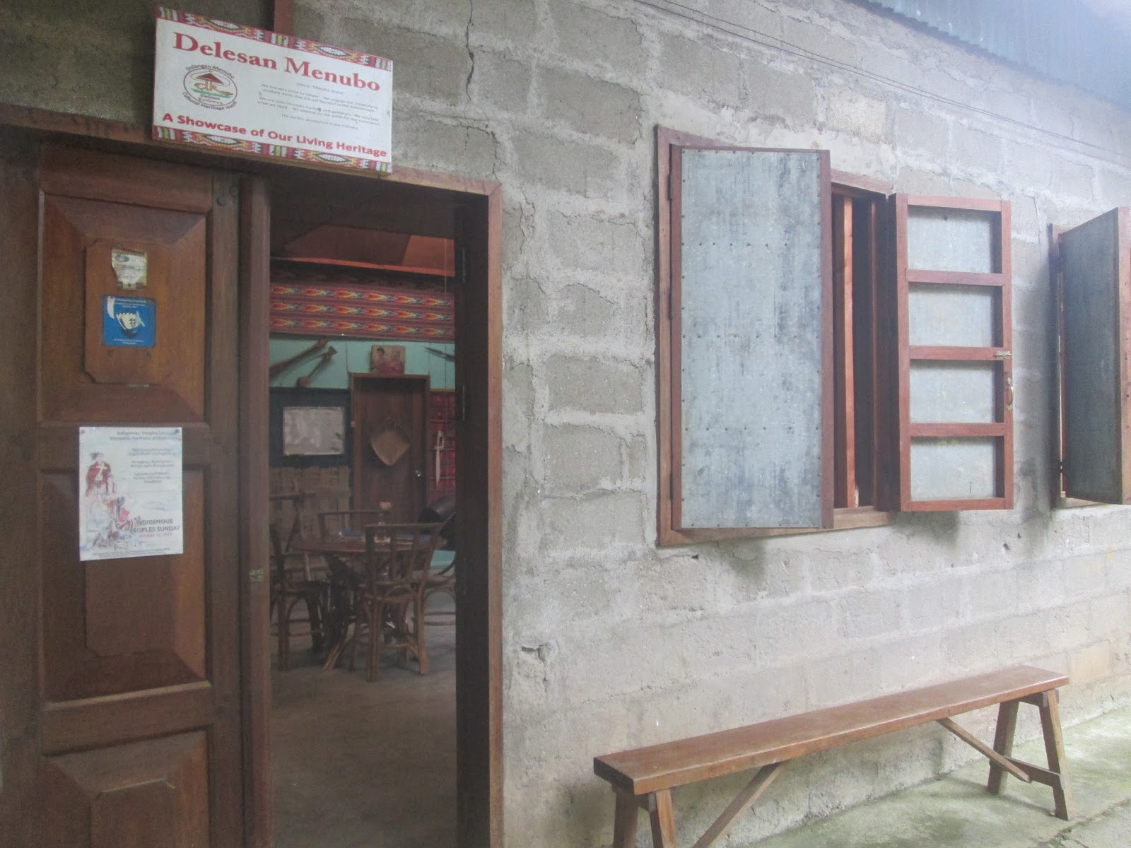
The compound is indeed a home. Well-maintained gardens surround the structures. When you enter the gates, a paved footpath leads you to Tegasalibatun, a two-story “place of welcome.” The nuns who welcomed my companions and me came out of the building, so I assume it is where the nuns and their scholars stay. Beside Tegasalibatun is a one-room structure, which must be a chapel. Retrace your steps, but instead of going back to the gates, walk to a structure that looks like a classroom. It is partially hidden from the gates because the ground it is built on is slightly sunken. The room is Delesan Menubo, which literally means “Menubo home.” It is where the tribal objects are found. It was my main destination. I spent a long time inside it during my visits, taking photos and identifying the displayed objects (which have not been labeled yet) with the help of the Manobo scholars who were around.

Attached to Delesan Menubo is a large shed made of wood and kalakat (weaved African palm). It’s Keseteponoy, which means “gathering.” It’s where meetings, trainings, and related activities are conducted. During my visits, I noticed a few Manobo women and their children coming from the direction of Keseteponoy and peeking at me and the Manobo girls in the Delesan Menubo, curious about what we were doing there. The Manobo girls told me that the women and children were patients. One toddler had two deep gashes on her head which probably started as mere itchy spots. There was apparently a clinic inside the compound. But I didn’t see the clinic. All I can share with you now are photos of Tegasalibatun, Delesan Menubo, and Keseteponoy. As to the traditional Manobo objects, I’ll share their photos with you next year, a few months from now, after I’ve checked and rechecked their names.

Tegasalibatun, where the RNDM sisters and their female Manobo scholars stay


A chapel beside Tegasalibatun


Delesan Menubo, the room where Manobo items are on display

The Manobo girsl who helped me identify the objects in Delesan Menubo.
As I read the items in my prepared list, they pointed the samples to me. 


Keseteponoy, where trainings and meetings are held

Friday, October 3, 2014

Where the Sky Is Seldom Blue

Wherever you are in Kulaman Plateau, you will never lack for scenic views to take photos of. The only thing that can be frustrating is that you rarely get bright sunlight, causing your photos to look dull and gloomy. Or at least for amateur photographers like me. Perhaps if you’re skilled enough and you have state-of-the-art equipment, your photos will come out the way you want them to be regardless of the weather.

Most of the time, the weather in the plateau is cloudy. Expect rain to fall at least four or five times a week. In many parts of the plateau, especially the most elevated ones, wind doesn’t seem to stop blowing. A jacket is an essential part of one’s wardrobe here. I actually wear one every day and for most of the day, though most of the other locals only wear theirs when it’s raining or particularly windy. For the wash to be completely dry, usually you have to hang it on a clothesline for at least two days.

I’m posting today two photos that I think would have been more stunning had there been bright sunlight when I took them. I took one in a fallow rice field recently and the other on the way to Ilyan Hill about a year and a half ago. I didn’t fully realize the effect of a clear blue sky to a photo until I took a shot of our marang tree in the yard one sunny day. One fruit was something like Siamese twins; the stems and the globed fruits were joined as though they were sharing a heart or a brain. That was what I wanted to capture. But what fascinated me more was the sky in the background. It was so blue that it intensified the colors of the other objects in the photo. I had a photo of the same tree days before, and it was taken in an almost similar angle, so I looked for it and compared it to the newer photo. I combined the photos and posted the output here, in addition to the two photos mentioned previously, so that you can see the difference for yourself.

I guess you can never have everything, or you should grab every chance that you can have everything. From now on, whenever I see the sky blue and clear, I’ll drop everything, get my camera, and shoot the scenic views around me. I hope to give you much more beautiful photos in future posts.


A bird perches on a makeshift stand, where a person stays to guard the rice field against sparrows. The rice field is normally surrounded by a string. When sparrows come near to feed on the grains, the guard pulls the string, causing the crude streamers attached to it to shake and scare the birds away.


My brother (in blue pants) and his classmate when the three of us trekked up Ilyan Hill, more than a year ago


The marang tree in our yard. Notice the difference a bright sunlight makes.

Friday, September 5, 2014

Tinalon Cave Resort


The official name of the resort is Elan’s Haven. But if you’re asking directions from the locals, just say “Tinalon swimming pool.” If you use the official name, the person you’re asking might think you want to go to heaven. The entrance fee is P25 for an adult and P10 for a child. Cottage fee is P150.


The resort has two swimming pools. One has a depth of four to five feet, the other two and a half feet. The walls and floors, made of concrete, are slippery with moss, so you must be careful.


The water in the swimming pools comes from the stream that flows through a cave. If you
peer at this photo closer, you can see the small mouth of the cave under the trees. We didn’t go inside the cave because you have to pay P15 per head and P100 for the tour guide. You also have to rent flashlights for P20 each, and the flashlights look as though they were bought for P20. I guess the prices are affordable enough for those who come from urban areas, but my relatives and I are not willing to waste such an amount because there’s also a cave in our farm in another village. We can go in and out of “our” cave as often as we want without paying a single centavo, and according to persons who have been to both caves, the two look as ugly.


The murky koi pond. There’s still so much to be improved in the resort, but for now, it’s the best in Kulaman, so just love your own, I guess. The water in the swimming pools is fresh and cold anyway, and it doesn’t hurt if you open your eyes underwater.


The gardens in the resort are not well-maintained, but I like this spot.

Monday, June 24, 2013

The Hidden Treasure of Kulaman (Part 2 of 2)

(The first part of this post appeared on May 13, last month.)

Something was telling Santiago not to walk straight ahead into the darkness. He groped at the wall of the cave and treaded on the muddy slope. He climbed down for about thirty meters before his flashlight shone on even ground. He stared back at where he had come from, and was horrified at the sight of a steep cliff a dozen times his height. If he did not keep close to the wall, he would be digging his grave instead of gold. The cave was a fully enclosed cathedral. It did not have a huge doorway in front. The only opening it had was a small window on top of the bell tower.

He continued exploring the cave. In a short while, the beam of light from his flashlight hit something lightly colored. He examined it closely. It was an oddly shaped column that stood taller than he. It looked like a very tall coral, but its surface was smooth and as white as milk. It looked soft and even edible, but when Santiago touched it, his finger curled at the hardness of the stone. It felt much more compact than concrete.

Santiago wondered if he could sell the thing, if it would fetch as high as the price of gold. He thought right away, though, that cutting the oddly shaped column is much more difficult than digging a hole. He walked on—and found hundreds of similar stone formations, competing with one another in size and grandeur and strangeness. Santiago trembled in awe. God seemed to have coated the whole interior of the cave with thick, divine white paint. It was his secret playground. Santiago fell to his knees. At last, he found the treasure he had been looking for. It was not in the form of gold, and it was something he would not want to sell.

Now, eight years since, Santiago visits the cave regularly, taking along with him tourists, spelunkers, and speleologists. The tourists usually whine on the long and torturous trip. Santiago assists them with their needs and just smiles to himself. He witnesses such a situation often. He knows that when the visitors reach the cave, they will utter one pleasant interjection after another and say all the hardship is worth it. He receives a modest commission from the fee that visitors pay the local government. It's just enough to get by, but he's not complaining. He's happy. He's got something more precious than gold, something priceless. In the cave, people tell him they have not seen anything more beautiful.


Monday, April 15, 2013

Ilyan Hill

Ilyan Hill is one of the landmarks of Kulaman. It stands out among hundreds of hills because its one side is rocky and dips abruptly whereas the other hills slope gently in almost all sides.

Ilyan Hill as seen from the highway in Barangay Buenaflores.
Photo by M. Linan.

The hill’s peculiar shape has inspired tales about it. The Dulangan Manobo have a legend on how the land formation got its name. The account in the next paragraph is taken from a paper by University of the Philippines professor Rosario Cruz-Lucero. It’s originally in Tagalog, and I translated it into English. Cruz-Lucero spelled the name Iliyan, but I prefer to use Ilyan because it’s closer to how the people here pronounce it.

A long time ago, Ilyan Hill was ordinary and had no name. It wasn’t different from the hills standing along it. A hunter named Ilyan was living at the foot of the hill. One day, he left his home to hunt. When he came back, he found M’lat Kum’l, an evil supernatural being with a hundred thumbs. M’lat Kum’l claimed for himself Ilyan’s house and land. Ilyan disappeared, and a hill rose where his house and land had been. This is why the hill is named after him.

I have yet to climb Ilyan Hill. It’s in my bucket list.

Monday, April 8, 2013

Kulaman River

This is Kulaman River. If you are traveling from the lowland towns of Sultan Kudarat, this body of water is the indication that you are entering the village of Kulaman, the seat of government of the municipality of Senator Ninoy Aquino. The river is the major vein that runs through the heart of Kulaman Plateau.


Kulaman River as seen from the bridge in the national highway. The photo at the top shows the water flowing toward the bridge, and the photo below shows the water flowing downstream, away from the bridge. Courtesy of M. Linan.


Local legend has it that the river is where Sultan Kulaman drowned in the seventeenth century. In the next paragraph is the story according to a paper by University of the Philippines professor Rosario Cruz-Lucero. It is written in Tagalog, and I translated it to English.

A long time ago, the old name of Kulaman River was Matihaw.  A long period of drought occurred. Matihaw River dried up. Kulaman dug up the mud in search of food, and he caught a fish. He informed his tribesmen of his find, and they happily went to the location of the fish. They slept there that night. A heavy rain suddenly came. Matihaw River flooded, and Kulaman drowned. That’s why the river is named after Kulaman.

It’s only the river and the village that are named after Kulaman. A whole town, too. Kalamansig (the town where Barangay Kulaman used to be a part of before becoming the capital village of Senator Ninoy Aquino in 1989 got its name from the phrase Kulaman suwayeg, which means “Kulaman in the river.”

A spot in Kulaman River. Motorcycles often pass through this shortcut, for the bridge is a couple of kilometers away from the center of the town. For five pesos, a “ferry,” made of bamboo poles tied together, can carry you and you vehicle across the river. A Manobo man propels the ferry forward by pulling on a rope tied to both banks of the river. The kid in the center is taking a bath and soaping his hair. Photo by M. Linan.

Monday, March 18, 2013

Tinalon Cave Resort

Words flow out of my mind faster when I write personal essays, so to keep the momentum, I’ll continue writing about my experiences in Kulaman Plateau and take some breather from summarizing or quoting academic texts. As a follow-up to my posts on the hundred caves of Kulaman, I’ll feature today the one that is in the village of Tinalon.

Along with Lagbasan Cave, Tinalon Cave Resort is the tourist spot in Kulaman that has a strong presence in the online world. I see pictures of the resort in Facebook, and I’ve been planning for some time now to go back there and take a wide-angled photo for my Facebook cover. For now, though, let me just narrate my experience there two years ago. People I know say nothing much has changed since, so my descriptions may still be accurate.

Photo from here. No copyright infringement intended.

I wasn’t able to go inside the cave. The mouth was small and you had to squeeze through to get inside. Not enticing. The cave anyway, was not really the main attraction there. Most locals went there to swim. The resort had two swimming pools, one for children and another for adults. The best thing about the place was the water, coming from the stream flowing out of the cave and carried to the pools by large black pipes.

The water, however, was too cold for me. I had just got back to Kulaman then, after staying most of the time away from home for more than ten years. I had been used to the hellish temperatures of Isulan, Koronadal, and Cebu, and Kulaman felt like the North Pole to me. It didn’t help that it was drizzling when my companions and I went to Tinalon. I dove into the water, paddled like a dog, and sat on the edge of the pool shirtless and shivering. I didn’t so much as dip my fingers into the water again. Now that I’m used to the temperature of Kulaman, though, I’ll probably enjoy the water in Tinalon Resort.

As to the cave, some relatives who had been inside told me that it wasn’t much different from other caves. If you came to Kulaman for spelunking, it’s better to head straight to Lagbasan Cave.

The swimming pools in Tinalon were rather crudely made. The floor wasn’t tiled and was thick with moss, making it slippery and a little dangerous. Cottages for an overnight stay were available. It was a good place for a honeymoon. For the whole day you could swim, go inside the cave, swim again, and go inside the smaller cave (wink). If you’re the type who likes swimming in a chlorinated pool with artificial waves, Tinalon Resort is not for you. But if you’re a nature-loving backpacker, Tinalon’s simple beauty will charm you. 

Monday, March 11, 2013

Lagbasan Cave

The previous post, I wrote about the mystical cave of Tacupis, whose beauty was marred by human activities. Fortunately, the same thing might not happen to the well-preserved Lagbasan Cave.

I don’t know when exactly the cave was discovered, probably not more than ten years ago. It is touted to be world-class and was the main site of a Mindanao-wide spelunking summit a few years ago.

I’m dying to visit the cave myself, but because I have other priorities now, I will have to give you secondhand information again. My excuse is that this is a research blog, not a personal adventure or travel blog. So I’m afraid all I can do is recount the story of my cousin who had been inside the cave and give you related links to online forums and other blogs.

As to the links, however, it looks like there are only a few that are worth your time. When I googled “Lagbasan Cave,” most of the results led me to search engine–optimized blog posts that contained useless crap. The following sites, though, have some nice photos and helpful info:
I have a feeling that, unlike most things, the huge gypsum flowers look more magical when seen in the actual site than in photo. Going inside Lagbasan Cave should be in my bucket list.

A cousin of mine and her friends went inside the cave sometime last year. She said the cave was about two hours away by motorcycle from Kulaman proper. The entrance fee was P250 per head, but her group haggled with the tour guide (which I suggest you don’t; help boost the tourism income of the local government). Only one chamber was open to the public, and a special permission was needed to see the other chambers. The cave’s mouth was small. My cousin and her friends had to crawl through the opening one at a time. But all the difficulties, especially the torturous motorcycle ride on muddy road and the long walk through dense thickets, were worth it, she said.


Monday, March 4, 2013

The Hundred Caves of Kulaman

I like saying “the hundred caves of Kulaman.” It sounds like “the hundred islands of Pangasinan.” I hope the former phrase will be as well known as the latter.

I first heard about the three-figure caves of Kulaman Plateau in a promotional video on Sultan Kudarat Province, which I featured in a previous post. At first I thought the number was an exaggeration. A hundred caves in just one town. Are you kidding me? But when I googled more about caves and read about karst topography, I learned that Kulaman indeed might be more holey than I knew. Beneath the mostly slash-and-burned land could be a maze of tunnels formed for thousands of years by acidic water eating into limestone.

Karst means “an irregular limestone region with sinks, underground streams, and caverns.” I have not seen any official-looking website describe Kulaman’s topography as karstic, but an adventurer or so have done so in an online forum. Judging by what I know of Kulaman firsthand, the description may be accurate.

The limestone burial jars that are now in Cebu City were found in the caves in the western part of Kulaman Plateau. A decade or so ago, world-class caves were discovered in the hamlet of Lagbasan, and the site has since drawn considerable attention from the spelunking community. I’ve heard of several more cave sites in the plateau, but I’ve gone to only one of them, a large-mouthed cave in the village of Tacupis.


Me and my mum in the mouth of Tacupis Cave, stretching out the wings of hapless bats

I mentioned the cave in an essay that was published in the Philippine Daily Inquirer. It is quite an accessible cave, only a hundred meters or so from the road. (The road, though, isn’t so accessible.) It is even likely that a settlement appeared in the area because of the cave. From the cave’s mouth, about ten feet high and twenty feet wide, gushes forth a steady stream, which didn’t dry up even during the worst days of El NiƱo in the late nineties.

The cave is beside the farmland my mother and her siblings own, and I went inside it with about twenty relatives when I was six or seven. I found the cave beautiful, but not really breathtaking or awesome. The soil near the mouth was muddy, but the sand deeper inside was smooth. The water was cold and fresh. The stalactites were huge (to me, then). And hundreds of bats flapped noisily around. They were closely knit animals, because they huddled together in the ceiling, forming dark circles here and there.


Me on my uncle’s shoulders, with muddy legs and reaching up a nest of bats

Now a weird thing happened during that spelunking experience. Before we went to the cave site, my aunts and uncles talked about the figure of a naked woman sculpted on the wall of the cave, so I expected to see it. On our way to the cave, two cousins my age rushed ahead of the party. I followed them but wasn’t able to keep up. When I reached the front of the cave, the two boys were already inside, but still near the mouth.

My cousins could not keep aflame their mitsa, an improvised lamp made from a rum bottle with a piece of cloth as a wicker and kerosene as fuel. Nobody brought flashlights because my uncles and aunts believed engkantos (fairies) living in the cave would make modern gadgets malfunction and we could be trapped inside. When the other boys lit up the mitsa one more time, I saw the cave glow in green light, and I saw the sculpture on the wall. The woman had long hair and was naked.

The flame of the lamp petered out again. The next time it was lit, reddish light bathed the cave and the woman on the wall.

The others arrived and we all went inside. I didn’t enjoy much the adventure. I was trembling all the time because everything—the air, the water, the soil—was cold. I was also scared because a bat might bite me in the neck and the whimsical engkantos might decide not to let us out of the cave.

Fortunately, the engkantos didn’t feel like playing tricks on us that time. We got out of the cave alive, unharmed, no one of us missing, and with live bats as souvenirs. (I brought a couple of bats to my grandmother’s house in the next village, where my family spent the next night. I left the teeny-weeny stinky creatures hanging on a bamboo stick in the kitchen. When I woke up in the morning, they were gone.)

I didn’t tell anyone about the woman on the wall, thinking everyone else had seen it. More than ten years later, when I was already seventeen or eighteen, a cousin and I happened to talk about the cave. He lived on the family farmland, so he was quite familiar with the cave. When I mentioned the sculpture, he told me I could have not seen it because some treasure hunters had torn it down a few years before my visit. I insisted I really saw a woman and told my cousin about the green and red light. He insisted that there was no longer a woman there. I let the topic go and wondered, even up to this day, what I really saw.

Hmmm. The mystical cave of Tacupis? More on caves next week.